Projet de numérisation du fonds cartographique du laboratoire de graphique

[Annotation #642054]

Annotation

Propriétaire

Créé

2019-02-02 22:30:34

Métadonnées

Motivated by

locating

styledBy

{"leaflet-interactive":{"pane":"overlayPane","attribution":"","bubblingMouseEvents":"true","color":"#34495e","dashArray":"10, 10","fillOpacity":"0","fill":"true","smoothFactor":"1","noClip":"false","stroke":"true","weight":"3","opacity":"1","lineCap":"round","lineJoin":"round","dashOffset":"","fillColor":"","fillRule":"evenodd","interactive":"true"}}
Bodies

#1

value

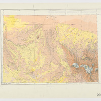
Emprise de la carte

hasPurpose

describing

Targets

#1

type

oa:Selector

Format

application/wkt

value

POLYGON ((11.999581 24.250946, 12.999328 24.265663, 13.996811 24.276553, 15.992683 24.278066, 18.363802 24.243581, 18.359265 23.997147, 18.313184 21.999863, 18.267743 20.000563, 17.000349 19.998994, 14.999152 19.999562, 12.999836 19.999801, 11.999701 19.999084, 11.99982 20.999698, 11.998625 22.499005, 11.999581 24.250946))

styleClass

leaflet-interactive

Uncertainty

Known