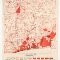
Carte démographique d'Afrique Occidentale au 1:1 000 000e, 1953, N°5
Contenu
Identifiant
FR
52
doi
FR
_
Chemise
FR
_
Titre normalisé
FR
Carte démographique d'Afrique Occidentale au 1:1 000 000e, 1953, N°5
Titre brut
FR
CARTE DEMOGRAPHIQUE DE L'AFRIQUE OCCIDENTALE [ ] Feuille n°5
Recto/verso
FR
_
Support
FR
_
Format
FR
2 feuillets ; 1. 66 x 53 ; 2. 71 x 52
Type
FR
Carte thématique
Résumé
FR
Carte démographique de l'Afrique Occidentale (Niger, Burkina Faso, Togo, Bénin) au 1:1 000 000 en 1953
Langue
FR
FRA
Bounding box (WKT)
FR
65 : MultiPolygon (((0.00019377 11.00022452, 4.50386952 11.0004721, 4.49941307 7.50364452, 4.49600884 5.99711691, 3.30093756 6.00182095, 0.00068893 5.99835482, -0.00079656 8.39542963, 0.00019377 11.00022452))); 66a : MultiPolygon (((-0.00110005 16.99958769, 2.43869423 16.99072244, 4.50151721 17.00104317, 4.50204648 11.99469486, 4.49940014 11.00205227, 4.50151721 10.89514008, 4.11250505 10.89672789, 3.07196369 10.89672789, 2.10446134 10.89566935, 1.37301262 10.89778642, -0.0007031 10.91498764, -0.00110005 16.99958769))); 66b : MultiPolygon (((1.59932689 6.81677943, 2.07623539 6.8172021, 3.00905995 6.82086521, 3.00286084 5.99455256, 1.59467756 5.99469345, 1.59932689 6.81677943)))
FR
65 : -0,00079656; 66a : -0,00110005; 66b : 1,59467756
FR
65 : 4,50386952; 66a : 4,50204648; 66b : 3,00905995
FR
65 : 5,99711691; 66a : 10,89514008; 66b : 5,99455256
FR
65 : 11,0004721; 66a : 17,00104317; 66b : 6,82086521
FR
1:1 000 000
FR
WGS 84
Date de la création du document
FR
1953
Date de la publication du document
FR
1953
Date de la dernière modification du document
FR
1953
FR
29/10/2017
Période concernée par le document
FR
_
FR
1953
Se conforme à
FR
Carte ancienne
Détails de la Licence du document au norme
FR
Démarche en cours ou sans réponse
Organisation actuelle détentrice des droits
FR
IFAN (Institut fondamentale d'Afrique Noire)
Mention de la provenance du document
FR
Ecole Pratique des Hautes études IV section carto, Archives nationales
Organisation ou personnes contributrices au document
FR
_
Organisation ou personnes créatrices du document
FR
P. Mercier
Organisation ou personnes ayant publié le document
FR
I.F.A.N.
Organisation reponsable des métadonnées
FR
Plateforme Géomatique de l'EHESS
Sources mentionnées par le document
FR
_
Sujet
FR
Limites
FR
Société
FR
Dénominations géographiques
FR
Unités administratives
FR
Hydrographie
FR
Répartition de la population — démographie
Couverture
FR
NE ; BF ; TD ; BJ
FR
Niger, Burkina Faso, Togo, Bénin
Licence
FR
_
Collections

Ressources liées
Filtrer par propriété
| Titre | Libellé alternatif | Classe |
|---|---|---|
| [Annotation #642145] | Annotation | |
| [Annotation #642143] | Annotation | |
| [Annotation #642147] | Annotation |
Annotations
| Value | Purpose |
|---|---|
|
Emprise de la carte
|
describing |
| Target selector | Selector type |
|---|---|
|
POLYGON ((0.000194 11.000225, 4.50387 11.000472, 4.499413 7.503645, 4.496009 5.997117, 3.300938 6.001821, 0.000689 5.998355, -0.000797 8.39543, 0.000194 11.000225))
|
oa:Selector |
| Value | Purpose |
|---|---|
|
Emprise de la carte
|
describing |
| Target selector | Selector type |
|---|---|
|
POLYGON ((-0.0011 16.999588, 2.438694 16.990722, 4.501517 17.001043, 4.502046 11.994695, 4.4994 11.002052, 4.501517 10.89514, 4.112505 10.896728, 3.071964 10.896728, 2.104461 10.895669, 1.373013 10.897786, -0.000703 10.914988, -0.0011 16.99…
|
oa:Selector |
| Value | Purpose |
|---|---|
|
Emprise du zoom de la carte
|
describing |
| Target selector | Selector type |
|---|---|
|
POLYGON ((1.599327 6.816779, 2.076235 6.817202, 3.00906 6.820865, 3.002861 5.994553, 1.594678 5.994693, 1.599327 6.816779))
|
oa:Selector |