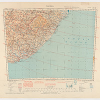
Africa au 1:2 000 000e : Natal, 1949
Contenu
Identifiant
FR
187
doi
FR
_
Chemise
FR
Afrique 1:2.000.000 (2002)
Titre normalisé
FR
Africa au 1:2 000 000e : Natal, 1949
Titre brut
FR
Africa 1:2,000,000 [ ] NATAL [ ] Third edition. Army/Air style [ ] South H 35-36 / I 35-34
Recto/verso
FR
recto
Support
FR
papier
Format
FR
61,5 x 89
Type
FR
Carte topographique
Résumé
FR
Carte topographique centrée sur le Natal au 1:2 000 000e en 1943
Langue
FR
ENG
FR
FRA
Bounding box (WKT)
FR
MultiPolygon (((23.99707372 -27.99018061, 24.99727368 -28.00086612, 26.00195082 -28.00337334, 28.00736517 -28.00910412, 30.99739893 -28.00767142, 33.98707452 -27.99943343, 36.0057413 -27.99137452, 36.00412952 -29.25572756, 36.00054778 -32.4133866, 36.00269682 -36.00765933, 35.00482499 -36.00336125, 32.99726159 -35.99548143, 30.99292176 -35.99154152, 28.00861878 -35.99321299, 25.00569077 -36.00515212, 23.99229807 -36.01088289, 23.99755129 -34.00511037, 23.99850642 -31.10151585, 23.99564103 -28.71369141, 23.99707372 -27.99018061)))
FR
23,99229807
FR
36,0057413
FR
-36,01088289
FR
-27,99018061
FR
1:2 000 000
FR
WGS 84
Date de la création du document
FR
1924
Date de la publication du document
FR
1949
Date de la dernière modification du document
FR
1943
FR
29/10/2017
Période concernée par le document
FR
_
FR
1943
Se conforme à
FR
Carte ancienne
Détails de la Licence du document au norme
FR
Démarche en cours ou sans réponse
Organisation actuelle détentrice des droits
FR
I.G.N.
Mention de la provenance du document
FR
Archives nationales
Organisation ou personnes contributrices au document
FR
_
Organisation ou personnes créatrices du document
FR
Geographical Section, General Staff N° 2871, Office Survey
Organisation ou personnes ayant publié le document
FR
War Office, I.G.N.
Organisation reponsable des métadonnées
FR
Plateforme Géomatique de l'EHESS
Sources mentionnées par le document
FR
_
Sujet
FR
Imagerie/Cartes de base/Occupation des terres
FR
Limites
FR
Transport
FR
Services d’utilité publique/Communication
FR
Altitude
FR
Dénominations géographiques
FR
Réseaux de transport
FR
Unités administratives
FR
Hydrographie
FR
Systèmes de maillage géographique
FR
Référentiels de coordonnées
FR
Services d'utilité publique et services publics
Couverture
FR
ZA
FR
Afrique du sud
Licence
FR
British Crown copyright reserved, Reproduit avec l'autorisation du Controller of His Britannic Majesty's Stationery Office)
Collections
Ressources liées
Filtrer par propriété
| Titre | Libellé alternatif | Classe |
|---|---|---|
| [Annotation #711994] | Annotation | |
| [Annotation #711999] | Annotation | |
| [Annotation #712003] | Annotation | |
| [Annotation #712005] | Annotation | |
| [Annotation #712007] | Annotation | |
| [Annotation #712011] | Annotation | |
| [Annotation #712015] | Annotation | |
| [Annotation #642875] | Annotation |
| Titre | Libellé alternatif | Classe |
|---|---|---|
| [Annotation #712019] | Value | Annotation |
| [Annotation #712023] | Value | Annotation |
Annotations
| Value | Purpose |
|---|---|
|
Emprise de la carte
|
describing |
| Target selector | Selector type |
|---|---|
|
POLYGON ((23.997074 -27.990181, 24.997274 -28.000866, 26.001951 -28.003373, 28.007365 -28.009104, 30.997399 -28.007671, 33.987075 -27.999433, 36.005741 -27.991375, 36.00413 -29.255728, 36.000548 -32.413387, 36.002697 -36.007659, 35.004825 -…
|
oa:Selector |
| Target selector | Selector type |
|---|---|
|
POLYGON ((3336.750031 565.125, 3336.750031 565.125, 3336.750031 565.125, 3336.750031 565.125))
|
oa:Selector |
| Value | Purpose |
|---|---|
| Target selector | Selector type |
|---|---|
|
POLYGON ((3337.25 565.624985, 3450 567.875, 3450.500031 481.625, 3340.75 478.375, 3337.25 565.624985))
|
oa:Selector |
| Target selector | Selector type |
|---|---|
|
POLYGON ((3449.000061 655.75, 3449.000061 570.25, 3563.5 567.25, 3566.500061 656.25, 3449.000061 655.75))
|
oa:Selector |
| Target selector | Selector type |
|---|---|
|
POLYGON ((3333 654.75, 3448 656.25, 3449.000061 568.75, 3336 567.75, 3333 654.75))
|
oa:Selector |
| Value | Purpose |
|---|---|

| Target selector | Selector type |
|---|---|
|
POLYGON ((3449.750031 656.625, 3449.5 568.625015, 3564.25 568.375015, 3565 655.375, 3449.750031 656.625))
|
oa:Selector |
| Value | Purpose |
|---|---|

| Target selector | Selector type |
|---|---|
|
POLYGON ((3333.500061 655.25, 3448.500061 657.249969, 3449.5 569.749969, 3337 568.25, 3333.500061 655.25))
|
oa:Selector |
| Value | Purpose |
|---|---|

| Target selector | Selector type |
|---|---|
|
POLYGON ((3627.000061 752.25, 3727.000061 748.25, 3719.000061 585.75, 3624.000061 588.25, 3627.000061 752.25))
|
oa:Selector |