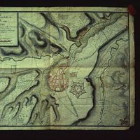
Jaca
Contenu
Titre
Jaca
Editeur
_
Sujet
Aucune
Couverture
Aucune
Couverture spatiale
Aucune
Provenance
Aragon2_Jaca
Créateur
Jean Passini (CNRS – EHESS / CRH)
Résumé
Carte itinéraire de Jaca
État du document
Bon
Identifiants des documents
5091
22
_
Numéro du document
2N37
Support
Diapositive
Format
Format diapositive
Langue
Français
Couverture temporelle
Aucune
Date de création
_
Date de publication
01/08/1985
Se conforme à
Prise de vue
Droits d’accès
Accès libre
page d’accueil
Plateforme Géomatique de l'EHESS
Ressources liées
Filtrer par propriété
| Titre | Libellé alternatif | Classe |
|---|---|---|
| [Annotation #698527] | Value | Annotation |
| Titre | Libellé alternatif | Classe |
|---|---|---|
| [Annotation #698714] | Annotation | |
| [Annotation #699102] | Annotation | |
| [Annotation #699108] | Annotation | |
| [Annotation #699114] | Annotation |
Annotations
| Value | Purpose |
|---|---|
|
Camino de tierra
|
highlighting |
| Target selector | Selector type |
|---|---|
|
LINESTRING (3899.14174 2912, 3155.066362 2280, 2859.036372 1616, 2963.046909 1096, 2571.007193 576)
|
oa:Selector |
| Value | Purpose |
|---|---|
|
Ciudadela de Jaca
|
identifying |
| Target selector | Selector type |
|---|---|
|
POLYGON ((2696.768211 1424, 2822.780977 1432, 2826.781382 1296, 2864.785232 1192, 2778.776519 1144, 2696.768211 1048, 2578.756256 1144, 2482.74653 1206, 2568.755243 1328, 2580.756459 1456, 2696.768211 1424))
|
oa:Selector |
| Value | Purpose |
|---|---|
|
Hospital
|
identifying |
| Target selector | Selector type |
|---|---|
|
POLYGON ((2496.814006 1688, 2688.833458 1678, 2674.83204 1574, 2496.814006 1550, 2496.814006 1688))
|
oa:Selector |
| Value | Purpose |
|---|---|
|
Camino de tierra
|
highlighting |
| Target selector | Selector type |
|---|---|
|
LINESTRING (3677.549796 2964, 2917.472797 2436, 2505.431055 2068, 2465.427002 1684, 2429.423355 1212, 2265.406739 1124, 1938.770521 584)
|
oa:Selector |