Aragón, plan topographique de Torre Espelunca
Contenu
Titre
Aragón, plan topographique de Torre Espelunca
Editeur
Instituto del Territorio y Urbanismo, MOPU, Casa de Velázquez
Sujet
Aucune
Couverture
Aucune
Couverture spatiale
*1:10000
Provenance
Maquette de El Camino de Santiago
Créateur
Jean Passini (CNRS – EHESS / CRH)
Résumé
Plan de Torre Espelunca
État du document
Bon
Identifiants des documents
5983
3
_
Numéro du document
_
Support
Papier découpé et calque sur papier A3
Format
42x29,7 cm
Langue
Espagnol
Couverture temporelle
Aucune
Date de création
_
Date de publication
1985
Se conforme à
Carte topographique
Droits d’accès
Accès libre
page d’accueil
Plateforme Géomatique de l'EHESS
Ressources liées
Filtrer par propriété
| Titre | Libellé alternatif | Classe |
|---|---|---|
| [Annotation #695187] | Annotation | |
| [Annotation #698247] | Annotation |
| Titre | Libellé alternatif | Classe |
|---|---|---|
| [Annotation #714187] | Value | Annotation |
Annotations
| Value | Purpose |
|---|---|
|
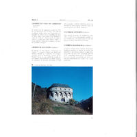
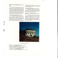
Torre Espelunca
|
identifying |
| Target selector | Selector type |
|---|---|
|
POINT (-0.523281 42.736631)
|
oa:Selector |
| Value | Purpose |
|---|---|
|
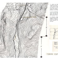
En 1869, el ministro de la Guerra autoriza la construcción de la carretera de Zaragoza a Francia, por Huesca, en sus tramos de Jaca a Francia, por Canfranc . Diez años después, en 1879, dos torretas fueron elevadas en un trozo de esta c…
|
identifying |
| Target selector | Selector type |
|---|---|
|
POLYGON ((1128.692022 1866, 1128.692022 1930, 1692.749164 1930, 1692.749164 1866, 1128.692022 1866))
|
oa:Selector |