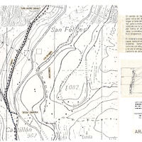
Aragón, plan topographique de Aratorés
Contenu
Titre
Aragón, plan topographique de Aratorés
Editeur
Instituto del Territorio y Urbanismo, MOPU, Casa de Velázquez
Sujet
Aucune
Couverture
Aucune
Couverture spatiale
*1:10000
Provenance
Maquette de El Camino de Santiago
Créateur
Jean Passini (CNRS – EHESS / CRH)
Résumé
Plan de Aratores
État du document
Bon
Identifiants des documents
5986
6
_
Numéro du document
_
Support
Papier découpé et calque sur papier A3
Format
42x29,7 cm
Langue
Espagnol
Couverture temporelle
Aucune
Date de création
_
Date de publication
1985
Se conforme à
Carte topographique
Droits d’accès
Accès libre
page d’accueil
Plateforme Géomatique de l'EHESS
Ressources liées
Filtrer par propriété
| Titre | Libellé alternatif | Classe |
|---|---|---|
| [Annotation #698137] | Annotation | |
| [Annotation #699832] | Annotation |
| Titre | Libellé alternatif | Classe |
|---|---|---|
| [Annotation #714203] | Value | Annotation |
Annotations
| Value | Purpose |
|---|---|
|
Aratorés
|
identifying |
| Target selector | Selector type |
|---|---|
|
POLYGON ((1929.466718 1580, 1929.466718 1896, 1997.473607 1896, 1997.473607 1580, 1929.466718 1580))
|
oa:Selector |
| Value | Purpose |
|---|---|
|
Aratorés
|
identifying |
| Target selector | Selector type |
|---|---|
|
POINT (-0.565125 42.657514)
|
oa:Selector |