Aragón, plan topographique de Baños de Tiermas
Contenu
Titre
Aragón, plan topographique de Baños de Tiermas
Editeur
Instituto del Territorio y Urbanismo, MOPU, Casa de Velázquez
Sujet
Aucune
Couverture
Aucune
Couverture spatiale
*1:10000
Provenance
Maquette de El Camino de Santiago
Créateur
Jean Passini (CNRS – EHESS / CRH)
Résumé
Plan de Baños de Tiermas
État du document
Bon
Identifiants des documents
6017
37
_
Numéro du document
_
Support
Papier découpé et calque sur papier A3
Format
42x29,7 cm
Langue
Espagnol
Couverture temporelle
Aucune
Date de création
_
Date de publication
1985
Se conforme à
Carte topographique
Droits d’accès
Accès libre
page d’accueil
Plateforme Géomatique de l'EHESS
Ressources liées
Filtrer par propriété
| Titre | Libellé alternatif | Classe |
|---|---|---|
| [Annotation #699845] | Annotation | |
| [Annotation #699836] | Annotation |
| Titre | Libellé alternatif | Classe |
|---|---|---|
| [Annotation #699849] | Value | Annotation |
Annotations
| Value | Purpose |
|---|---|
|
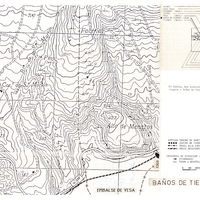
El camino bajaba hasta Baños de Tiermas, etapa que figura en la "Guía del peregrino" del siglo XII como un lugar "donde hay baños reales siempre calientes". Hubo ahí, en el siglo XIV, el hospital de peregrinos San Martín.
|
identifying |
| Target selector | Selector type |
|---|---|
|
POLYGON ((185.279893 60, 185.279893 236, 585.320419 236, 585.320419 60, 185.279893 60))
|
oa:Selector |
| Value | Purpose |
|---|---|
|
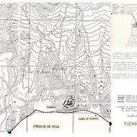
Tiermas
|
highlighting |
| Target selector | Selector type |
|---|---|
|
POINT (-1.116354 42.614958)
|
oa:Selector |