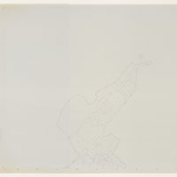
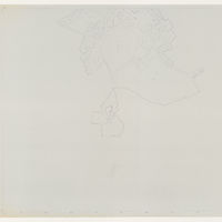
Navarra, plan topographique de Viscarret
Contenu
Titre
Navarra, plan topographique de Viscarret
Editeur
Instituto del Territorio y Urbanismo, MOPU, Casa de Velázquez
Sujet
Aucune
Couverture
Aucune
Couverture spatiale
*1:10000
Provenance
Maquette de El Camino de Santiago
Créateur
Jean Passini (CNRS – EHESS / CRH)
Résumé
Plan de Viscarret
État du document
Bon
Identifiants des documents
6047
8
_
Numéro du document
_
Support
Papier découpé et calque sur papier A3
Format
42x29,7 cm
Langue
Espagnol
Couverture temporelle
Aucune
Date de création
_
Date de publication
1985
Se conforme à
Carte topographique
Droits d’accès
Accès libre
page d’accueil
Plateforme Géomatique de l'EHESS

Ressources liées
Filtrer par propriété
| Titre | Libellé alternatif | Classe |
|---|---|---|
| [Annotation #701238] | Annotation | |
| [Annotation #701249] | Annotation |
| Titre | Libellé alternatif | Classe |
|---|---|---|
| [Annotation #712130] | Value | Annotation |
| [Annotation #712173] | Value | Annotation |
Annotations
| Value | Purpose |
|---|---|
|
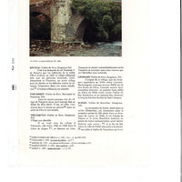
No sabemos casi nada del pueblo de Viscarret, excepto que existía ya a principios del siglo XII. En efecto, se menciona en la Guía del peregrino1 entre los puertos de Ciza y Larrasoaña.
|
identifying |


| Target selector | Selector type |
|---|---|
|
POLYGON ((4147.075277 208, 4147.075277 336, 4595.120666 336, 4595.120666 208, 4147.075277 208))
|
oa:Selector |
| Value | Purpose |
|---|---|
|
Viscarret
|
identifying |
| Target selector | Selector type |
|---|---|
|
POINT (-1.416771 42.967208)
|
oa:Selector |