Plan du cadastre de Puente La Reina
Contenu
Titre
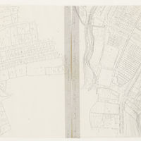
Plan du cadastre de Puente La Reina
Editeur
_
Sujet
_
Couverture
Ville
Couverture spatiale
*1:500
Provenance
_
Créateur
Jean Passini (CNRS – EHESS / CRH)
Résumé
Plan du cadastre de Puente la Reina
État du document
Bon
Identifiants des documents
1044
_
CSNAT-0252
Numéro du document
_
Support
Tirage papier
Format
77x44 cm
Langue
Espagnol
Couverture temporelle
Inconnue
Date de création
_
Date de publication
_
Se conforme à
Plan cadastral
Droits d’accès
Accès libre
page d’accueil
Plateforme Géomatique de l'EHESS
Ressources liées
Filtrer par propriété
| Titre | Libellé alternatif | Classe |
|---|---|---|
| [Annotation #701509] | Annotation | |
| [Annotation #701519] | Annotation |
| Titre | Libellé alternatif | Classe |
|---|---|---|
| [Annotation #701301] | Value | Annotation |
| [Annotation #713645] | Value | Annotation |
Annotations
| Value | Purpose |
|---|---|
|
Camino de tierra
|
highlighting |
| Target selector | Selector type |
|---|---|
|
LINESTRING (208.72262 1402, 336.735588 1460, 480.750177 1510, 654.767806 1584, 850.787664 1612, 1114.814411 1654, 1328.836093 1698, 1490.852506 1734, 2296.934166 1898)
|
oa:Selector |
| Value | Purpose |
|---|---|
|
Puente La Reina
|
identifying |
| Target selector | Selector type |
|---|---|
|
POINT (-1.815529 42.671711)
|
oa:Selector |