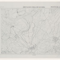
Plan topographique de Puente La Reina
Contenu
Titre
Plan topographique de Puente La Reina
Editeur
_
Sujet
_
Couverture
Comune
Couverture spatiale
*1:10000
Provenance
_
Créateur
Jean Passini (CNRS – EHESS / CRH)
Résumé
Plan parcellaire de Puente de la Reina
État du document
Bon
Identifiants des documents
1216
141-13
CSNAT-0288
Numéro du document
_
Support
Tirage papier
Format
84x69 cm
Langue
Espagnol
Couverture temporelle
Inconnue
Date de création
MM/YYYY
Date de publication
*01/*01/1975
Se conforme à
Plan parcellaire
Droits d’accès
Accès libre
page d’accueil
Plateforme Géomatique de l'EHESS
Ressources liées
Filtrer par propriété
| Titre | Libellé alternatif | Classe |
|---|---|---|
| [Annotation #701501] | Annotation | |
| [Annotation #701495] | Annotation |
| Titre | Libellé alternatif | Classe |
|---|---|---|
| [Annotation #701301] | Value | Annotation |
| [Annotation #713645] | Value | Annotation |
Annotations
| Value | Purpose |
|---|---|
|
Antiguo camino de Santiago
|
identifying |
| Target selector | Selector type |
|---|---|
|
LINESTRING (4590.902758 1728, 4548.898503 1658, 4496.893234 1600, 4448.888371 1558, 4416.885129 1492, 4374.880874 1420, 4350.878442 1354, 4316.874998 1310, 4272.87054 1274, 4216.864866 1242, 4160.859193 1226, 4106.853722 1226, 4034.846427 1…
|
oa:Selector |
| Value | Purpose |
|---|---|
|
Puente La Reina
|
identifying |
| Target selector | Selector type |
|---|---|
|
POINT (-1.815529 42.671711)
|
oa:Selector |