Tianjin
Recherche
Home
The Volunteers' collective inquiries
Radio Broadcast 话说天津卫
Maps
Until the end of Ming Dynasty (before 1644)
Qing Dynasty (1644-1911)
Republican Era (1911-1949)
Since 1949
Georeferenced Maps
Postcards
Streets
Districts
Waterway infrastructures
Monuments
Places of worship
Commercial hubs
Cultural facilities
Parks, gardens, city squares
Public services
Transport modes
Military, administrative areas
Buildings
Individuals
Contribute
Maps
> Until the end of Ming Dynasty (before 1644)
Until the end of Ming Dynasty (before 1644)
Bohaiwan Quanxinshi hai qin shiyitu 渤海湾全新世海侵示意图 [Schematic diagram of the Holocene transgression in Bohai Bay]
Tianjin cheng lu ji beike di, mu bian tan ceng fenbu shiyitu 天津成陆及贝壳堤、牡蝙滩层分布示意图 [Schematic diagram of Tianjin Chenglu and Beike dikes, and Mutian beach]
XiHan shiqi Bohaiwan xibei an zhu shui shiyitu 西汉时期渤海湾西北岸诸水示意图 [Schematic diagram of the waters on the northwestern coast of the Bohai Bay during the Western Han Dynasty]
Quanzhou yanbian shiyitu 泉州演变示意图 [Schematic diagram of the evolution of Quanzhou]
Han mo Tianjin diqu wa dian shiyitu 汉末天津地区洼淀示意图 [Schematic diagram of the swamp in Tianjin area in the end of Han Dynasty]
Han mo Haihe shuixi chubu xingcheng shiyitu 汉末海河水系初步形成示意图 [Preliminary diagram of the initial formation of the Haihe River system in the late Han Dynasty]
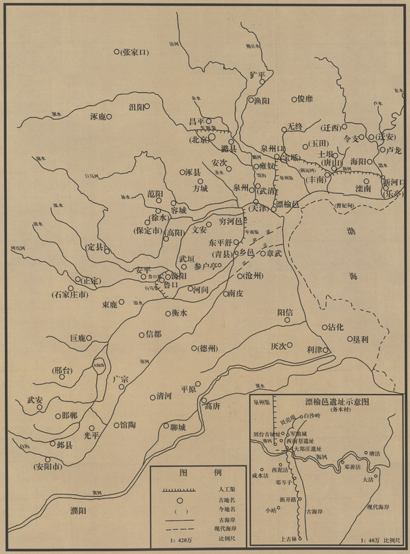
WeiJin Piaoyuyi yizhi ji shuixi huanjing shiyitu 魏晋漂榆邑遗址及水系环境示意图 [Piaoyuyi site and water system environment during the Wei and Jin dynasties]
Suidai Yongji qu de kaizao ji Haihe shuixi xingcheng shiyitu 隋代永济渠的开凿及海河水系形成示意图 [Schematic diagram of the excavation of the Yongji Canal in the Sui Dynasty and the formation of the Haihe River system]
Tangdai shuiyun shuniu junliang cheng ji fujin shuixi shiyitu 唐代水运枢纽军粮城及附近水系示意图 [Schematic diagram of the hub for army provisions waterbone transport during the Tang Dynasty and its nearby water system]
Jiehe nanbei Song, Liao duizhi shiyitu 界河南北宋、辽对峙示意图 [Schematic diagram of the frontier river between the Song and Liao dynasties]
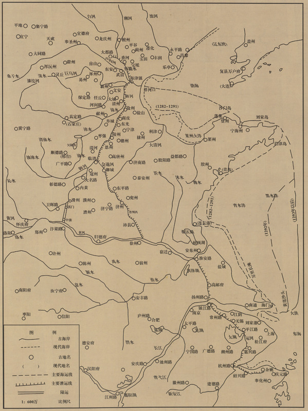
Jindai caoyun ji Xinan haiba, Zhiguzhai shiyitu 金代漕运及信安海壖、直沽寨示意图 [Schematic diagram of the waterbone transport and Xinan dyke of Zhigu village during the Jin dynasty]
Yuandai DaYunhe ji hai jin zhen shiyitu 元代大运河及海津镇示意图 [Schematic diagram of the Grand Canal and the ocean in Tianjin village during the Yuan Dynasty]
Mingdai Tianjin san wei jiangyu ji tunbao fenbu shiyitu 明代天津三卫疆域及屯堡分布示意图 [Schematic diagram of the distribution of Tianjin three garrison territories and positions of defense during the Ming Dynasty]
Mingdai haiyun tu 明代海运图 [Shipping map during the Ming Dynasty]
Mingdai heyun shiyitu 明代河运示意图 [Schematic diagram of the river transport during the Ming Dynasty]
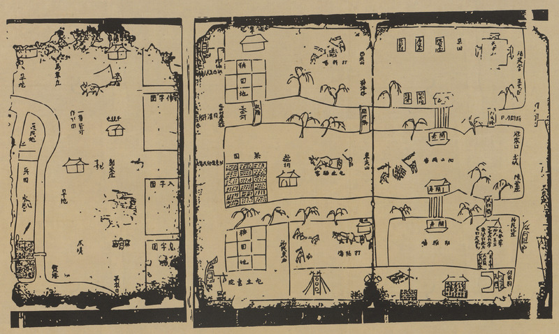
Mingmo Tianjin wei tunken tu (jubu) 明末天津卫屯垦图(局部) [Tianjin garrison troops map at the end of the Ming Dynasty (partial)]
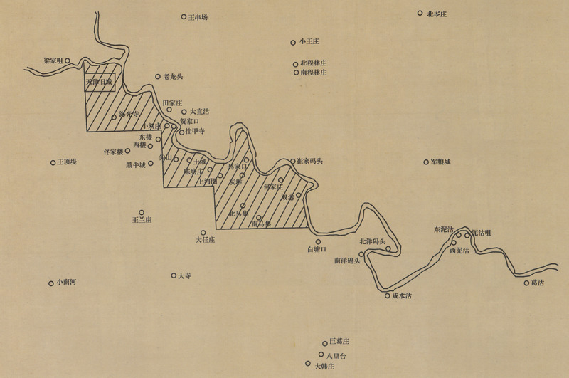
Tunken tu (jubu) fanwei shiyitu 屯垦图( 局部) 范围示意图 [Schematic diagram of the extent of the garrison troops (partial)]
Préc.
Suivant