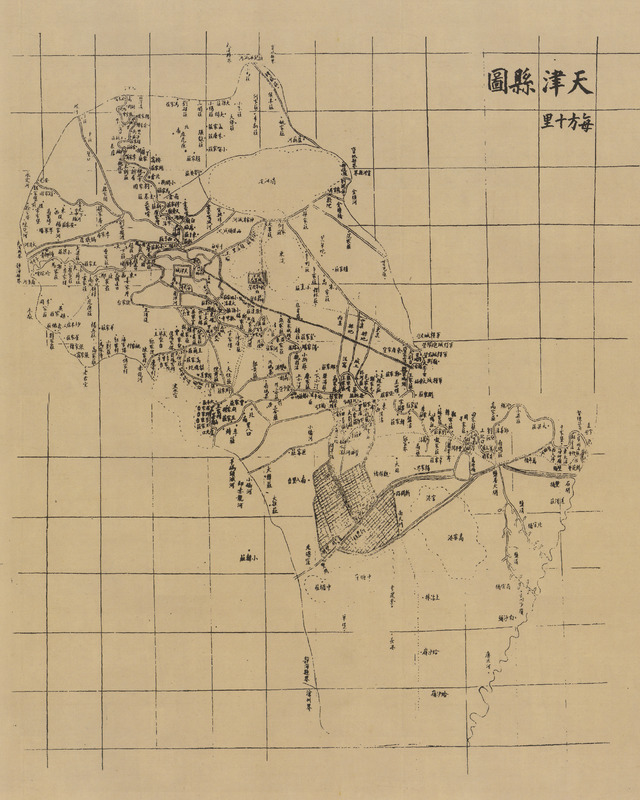
Tianjin xian tu [1899 nian (Qing Guangxu ershiwu nian)] 天津县图 [1899 年 (清光绪二十五年)] [Tianjin county map 1899 (Emperor Qing Guangxu 25 years)]
Contenu
Titre
Tianjin xian tu [1899 nian (Qing Guangxu ershiwu nian)] 天津县图 [1899 年 (清光绪二十五年)] [Tianjin county map 1899 (Emperor Qing Guangxu 25 years)]
Description
Quote from the book:
19 世纪 80 年代,天津城市迅速发展,尤其是唐津铁路的通车,大大促进了天津的繁荣。该图以计里开方的传统方法绘制,每方 10 (平方) 里,东西、南北各 12方,合计约 144平方里。
原图分为上、下两幅,现拼接为一幅。图中可见 1888年(光绪十四年) 通车的天津至唐山铁路的一段一 天津至军粮城区间。天津最初的火车站建于河东旺道庄,后于1892年(光绪十八年 ) 移至老龙头,即今天津站站址。
“天津县图”与前面的“天津府城图”及所附(天津) "郭图",均载于(光绪) 重修的《畿辅通志》,是目前保存比较详细的 19 世纪来的天津地图。原图规格均为 250mm x 230mm。
19 世纪 80 年代,天津城市迅速发展,尤其是唐津铁路的通车,大大促进了天津的繁荣。该图以计里开方的传统方法绘制,每方 10 (平方) 里,东西、南北各 12方,合计约 144平方里。
原图分为上、下两幅,现拼接为一幅。图中可见 1888年(光绪十四年) 通车的天津至唐山铁路的一段一 天津至军粮城区间。天津最初的火车站建于河东旺道庄,后于1892年(光绪十八年 ) 移至老龙头,即今天津站站址。
“天津县图”与前面的“天津府城图”及所附(天津) "郭图",均载于(光绪) 重修的《畿辅通志》,是目前保存比较详细的 19 世纪来的天津地图。原图规格均为 250mm x 230mm。
Identifiant
48
Black and white
Chinese
numéro d’édition
Tianjin chengshi lishi dituji 1404-2004 天津城市历史地图集 1404-2004 [Tianjin City History Atlas 1404-2004]
Tianjinshi guihua he guotu ziyuan ju bianzhu 天津市规划和国土资源局编著 [Edited by Tianjin Planning and Land Resources Bureau]
ISBN 7-80696-183-120
Tianjinshi guihua he guotu ziyuan ju bianzhu 天津市规划和国土资源局编著 [Edited by Tianjin Planning and Land Resources Bureau]
ISBN 7-80696-183-120
Guangxu chongxiu《ji fu tong zhi》光绪重修《畿辅通志》["The records of territory around the capital" revised version under Guangxu]
pages
p.74-75
Numéro
29
Couverture temporelle
1899
Format
250mm x 230mm
page d’accueil
École des hautes études en sciences sociales
Licence
CC/BY/NC (for the metadata)
Collections
Ressources liées
Filtrer par propriété
| Titre | Libellé alternatif | Classe |
|---|---|---|
| [Annotation #717756] | Annotation |
Annotations
| Target selector | Selector type |
|---|---|
|
POINT (1256.316555 3740)
|
oa:Selector |
