Zuixin Tianjinshi jie tu [1946 nian (Zhonghua Minguo sanshiwu nian)] 最新天津市街图 [1946 年 (中华民国三十五年)] [Latest Tianjin street map 1946 (Year 35 of the Republic of China)]
Contenu
Titre
Zuixin Tianjinshi jie tu [1946 nian (Zhonghua Minguo sanshiwu nian)] 最新天津市街图 [1946 年 (中华民国三十五年)] [Latest Tianjin street map 1946 (Year 35 of the Republic of China)]
Description
Quote from the book:
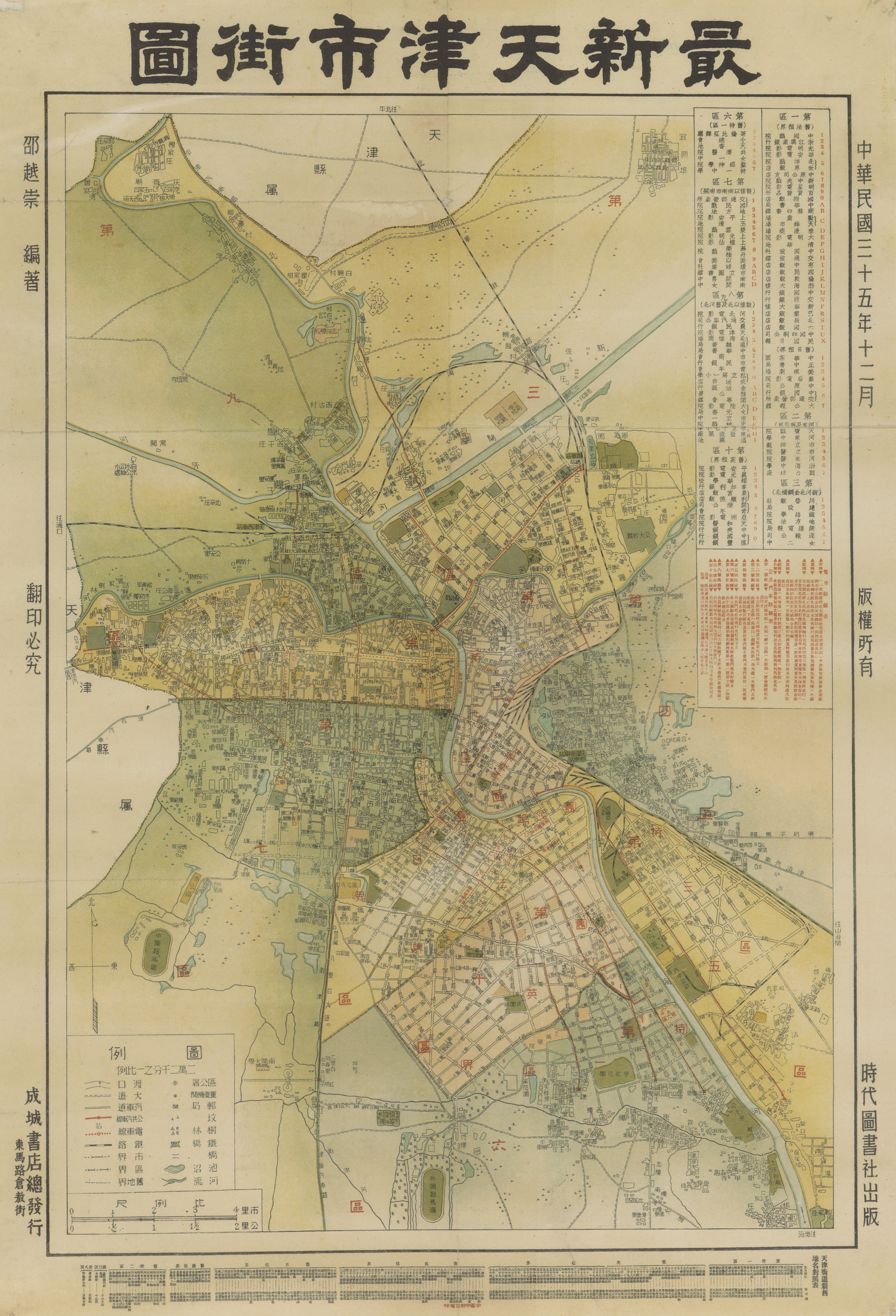
1945年 (中华民国三十四年) 日本投降后,天津的行政区划重新进行了调整,即由日伪时期的八个区,划分为十个区。第一区为原法、日租界; 第二区为老河东及原意租界; 第三区为金钢桥以北的河北新区; 第四区为京山铁路以东; 第五区为原俄租界; 第六区为旧特一区 (原德租界); 第七区为旧城厢鼓楼以南及南市、南开; 第八、九区为旧城厢及老河北; 第十区为原英租界。
该图为邵越崇编绘,1946 年 (中华民国三十五年) 12 月中国印刷公司印刷。
该图现藏天津图书馆,原图规格为800mm x 500mm。
1945年 (中华民国三十四年) 日本投降后,天津的行政区划重新进行了调整,即由日伪时期的八个区,划分为十个区。第一区为原法、日租界; 第二区为老河东及原意租界; 第三区为金钢桥以北的河北新区; 第四区为京山铁路以东; 第五区为原俄租界; 第六区为旧特一区 (原德租界); 第七区为旧城厢鼓楼以南及南市、南开; 第八、九区为旧城厢及老河北; 第十区为原英租界。
该图为邵越崇编绘,1946 年 (中华民国三十五年) 12 月中国印刷公司印刷。
该图现藏天津图书馆,原图规格为800mm x 500mm。
Identifiant
68
Coloured
Chinese
numéro d’édition
Tianjin chengshi lishi dituji 1404-2004 天津城市历史地图集 1404-2004 [Tianjin City History Atlas 1404-2004]
Tianjinshi guihua he guotu ziyuan ju bianzhu 天津市规划和国土资源局编著 [Edited by Tianjin Planning and Land Resources Bureau]
ISBN 7-80696-183-140
Tianjinshi guihua he guotu ziyuan ju bianzhu 天津市规划和国土资源局编著 [Edited by Tianjin Planning and Land Resources Bureau]
ISBN 7-80696-183-140
pages
p.110-111
Numéro
46
Couverture temporelle
1946
Date de publication
December 1946
Editeur
Zhongguo yinshuagongsi 中国印刷公司 [China printing company]
Sujet
Tianjin chengshi 天津城市 [Tianjin City]
Format
800mm x 500mm
Provenance
Tianjin tushuguan 天津图书馆 [Tianjin library]
Créateur
Shao Yuechong 邵越崇
page d’accueil
École des hautes études en sciences sociales
Licence
CC/BY/NC (for the metadata)
Collections
Annotations
There are no annotations for this resource.